|
National Parks |
Hotels in:
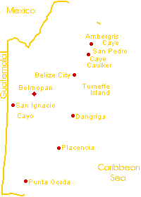
Reefs & Cayes
|
Maya Mountains: Parks and Places Blue Hole National Park Five Blues Lake National Park Other possible wildlife to see include coatamundi, collared peccary, agouti, many species of birds. Five Blues is one of the newest parks in Belize so there are fewer visitors and you can get a real feeling of exploration. Especially impressive are the towering limestone cliffs all around the area, a favorite haunt of the spectacular White Hawk and Black Hawk Eagle. 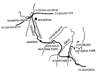
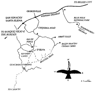
Chiquibil National Park and Caracol The birding is special. Although the forests around Caracol and in the Park are extremely high there is a solution for frustrated bird watchers. By climbing the Mayan Sky Palace, 140 feet high, you're suddenly right up there overlooking the trees to Guatemala, only four miles away. There are often raptores circling the skies overhead, and a good number of parrots. This is the centre piece of the many structures that form Caracol. Cockscomb Basin Wildlife Sanctuary & Jaguar Preserve This stunning sanctuary in southern Belize covers an area of about 150 square miles of tropical forest, and contains the world's only Jaguar Preserve. Declared a Forest Preserve in 1984 and finally a Jaguar Preserve in 1986, logging and periodic hurricane damage have left their almost indelible marks on the lush but vulnerable forests of southern Belize. Dense secondary growth is interspersed with the more mature stands of trees where the forest floor is relatively clear and the canopy ranges in height from 40 to 120 feet. Rainfall is high, and the runoff from the surrounding mountains provides the Cockscomb Basin with a plethora of creeks and streams. These come together to form the headwaters of some of southern Belize's major rivers such as the Swasey, the Sittee and South Stann Creek. The Jaguar (Panthera onca) is the third largest member of the cat family and endangered in most of its range. Here at Cockscomb, the Jaguar is doing quite well (an estimated 200 live here) but is by no means the only beneficiary of the safety of the preserve. Please note that a visit to the Jaguar Preserve may likely provide you with signs of recent Jaguar activity, but it is highly unlikely that an actual Jaguar sighting will occur. These wonderful animals are masters of stealth and their very existence is based on their seeing, but not being seen. Not only are the Jaguar still hunting these mountains, but other cats such as the Puma, Ocelot, Jaguarundi and Margay still survive here too. To feed them, healthy populations of Peccary, Paca, Brocket Deer, Tayra, Otter and Coatimundi, difficult to achieve in most locations, also roam these forests. Cockscomb is also renowned for its bird populations and boasts up to 300 recorded species. These include Macaw, the Great Curossow, yellow-winged tanagers, red-capped manikins, yellow-breasted great kiskadee, keel-billed Toucan... and on and on. In short, this is a park that you can come for a day, week or a year and not see the same things twice. The trail system is excellent and well marked... and the odds of having problems with anything other than the rain are remote. Columbia River Forest Reserve Mountain Pine Forest Reserve Not surprisingly, the reserves wildlife is very different from the lowlands. Certainly, birds can be quite hard to see secreted away in the scrub around the pines but there are exceptions. Acorn Woodpeckers are busy around D'Silva Forest Station causing great aggravation by hammering buildings, guttering and telegraph poles. Their habit of storing acorns in tree stumps will be familiar to visitors from North America, but for some reason, the Belizean ones do it as well, even though there's no harsh winter to survive. Other reserve specialties include the Rufous-capped Warbler, Crossbill, Pine Siskin, Stigeon Owl and Eastern Bluebird. If you visit between Autumn and Spring, you may also see the Hepatic Tanager and Chipping Sparrow. Raptors cruise the valleys of the Pine Ridge, and it's the most likely place in Belize to see Orange-breasted Falcons. A special part of the reserve is Baldy Beacon. Speculation continues on the cause of its infertility - soils are so poor they can't even support trees. Instead it's covered in grass so tough that when sheep were introduced as an experiment back in the 1960s, they died of indigestion! The most probable explanation for the infertility is that in geological history, while the rest of Central America was under water, protected from the elements, these parts were still above sea level and exposed to erosion and leaching for millions of years longer than anywhere else. The result is a set of rounded grassy hills, with views uninterrupted by any trees. Another different part to Mountain Pine Ridge is the areas that did have limestone deposited on them. These now support broadleaf forest, and the most spectacular example is the Rio Frio caves area, the largest accessible limestone cavern in the country. Walk in a short way, and you can see out both ends. It's light enough you don't need a torch. Back outside, short trails are being developed by the Forest Department, who are in charge of the whole reserve. Also, within its boundaries are the Rio Pools, a popular site for a summer picnic, where the river cascades down into a narrow cavern strewn with granite boulders. It's a great place to spend some time enjoying the deep pools and clambering around the enormous granite rocks. In all areas, a common roadside flower is the yellow flowered St. John's Wort, conspicuous with delicate petals and sets of spike-shaped leaves. Although an adjacent private property, the 1,000 Feet Valley Falls and King Vulture Falls are also reached from Mountain Pine Ridge, capping off the area's attractions. |


 on about 40 yards before descending down a siphon through an echoing cave full of bats (and a few Cliff Swallows in the winter months), and later on re-emerges to join the Caves Branch River. If you're coming from Belmopan, you will already have driven over it. The surrounding limestone is full of caves, and it was only by tracing colored dyes that it was ever discovered that this was the hydrologic connection.
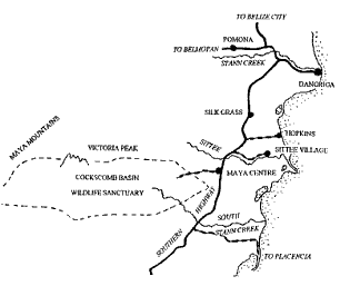 Cockscomb Mountain Range towers over the basin to the north. The highest mountain in Belize, Victoria Peak at 3,675 feet presides over the range and offers, in its largely unexplored reaches, chances for unrivaled exploration and adventure. The fine and abundant stands of mahogany and cedar have historically been in demand throughout this area and logging here provided a staple of Belize's economy for many years.
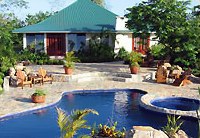
 Tropical Travel Association
|


and Guatemala!

...explore Tikal and the Mayan homeland.

...Central America's most magnificent city.

...the most beautiful lake in the world!.

...Guatemala's best beach.

...where business is done.

...getting there is half the fun!

...unique destinations for independent travelers.